

Day Trips
Las Cruces has that relaxed, small-city charm, a variety of lodging choices and conveniences. Conveniently nestled at the crossroads of two major Interstates and a main highway, Las Cruces is a homebase that offers quick access to nearby getaways.
WHITE SANDS NATIONAL PARK
Via Highway 70
53 minutes, 52 miles
White Sands National Park protects the world’s largest gypsum dune-field, and the unique plants and animals that survive in this other-worldly place. The magnificent pure white dunes provide excellent recreation opportunities; visitors can picnic, “white sand surf” or just stroll through 230 square-miles of the 275 square-mile national park. Home to the oldest human footprints in North America, the park offers tours and activities such as the sunset stroll nature walk, full moon hikes, special events, tours and more. www.nps.gov/whsa
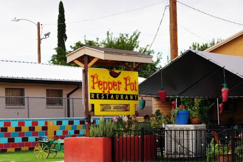 HATCH, NM
Via New Mexico Highway 185
39 minutes, 39 miles
Highlights of taking this route: It’s a back road through pecan orchards, agricultural areas and along the Rio Grande. Stop and hike Slot Canyon, Broad Canyon or Faulkner Canyon. Get drinks and food at the popular Blue Moon Bar in Radium Springs. Closer to Las Cruces, the highway offers access to Prehistoric Trackways and Fort Selden.
Via Interstate 25
59 minutes, 40 miles
Hatch, NM is “The Chile Capital of the World.” Stop by The Pepper Pot, the small town’s signature restaurant for New Mexican food. Right off the highway, check out Sparky’s Burgers, Barbeque and Espresso. Touting their green chile cheeseburger as “world famous,” the playful atmosphere, live music and exuberant statues scattered throughout the property offer ample photo-ops and good eats while passing through. Walk Main Street and check out other local spots.
TRUTH OR CONSEQUENCES, NM
Via Interstate 25
1 hour 10 minutes, 75 miles
Once called as Hot Springs, NM, the town of Truth or Consequences was renamed after a game show hosted by Ralph Edwards. Known best though for its hot springs, the small community is an oasis in the desert. Offering soaks both indoors and outdoors, and a downtown area with galleries, shops and dining, this small town is worth a visit. www.torcnm.org
ELEPHANT BUTTE LAKE STATE PARK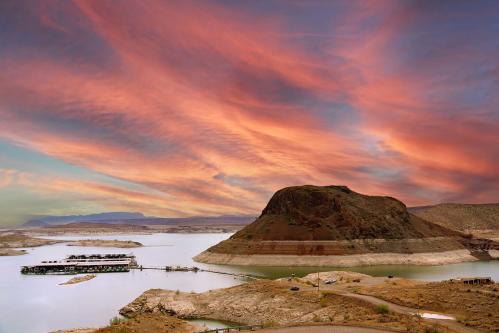
Via Interstate 25
1 hour 15 minutes, 79 miles
The largest of New Mexico’s state parks, Elephant Butte provides opportunities for camping and RVing, boating, fishing, hiking and swimming in a magnificent oasis in the desert. The area is named for the rock at the center of the lake resembling an elephant. The town of Elephant Butte also welcomes visitors with restaurants and recreational services. www.emnrd.nm.gov
CLOUDCROFT, NM
Via Highway 70 and US Highway 82
1 hour 33 minutes, 87 miles
A little closer to home, this small-town mountain getaway is perfect for outdoor recreation, hiking, biking, birdwatching, horseback riding and more. Walk along main street and stop by local shops, dine and discover the history of logging and railroading at the town’s museum. www.villageofcloudcroftnm.net
CITY OF ROCKS STATE PARK
Via Interstate 10, US Highway 180 and New Mexico Highway 61
90 minutes, 96 miles
Located just off Interstate 10, the “city” is described by the Energy, Minerals and Natural Resources Department as sculpted rock columns, rising as high as 40 feet and separated by paths resembling city streets. They are said to have been formed nearly 35 million years ago following a volcanic eruption. The park is perfect for camping, hiking, biking, birdwatching, stargazing, picnicking and more. Campers have access to restrooms and showers. www.emnrd.nm.gov
RUIDOSO, NM
Via Highway 70
2 hours 8 minutes, 118 miles
Ruidoso, NM offers the perfect mountain getaway. Located nearly 12,000 feet above sea level, the small town is home to Ski Apache. Outdoor recreation is also a big part of its appeal with skiing in the winter, mountain biking in the summer, zipline tours, camping, golfing, fishing and more. Check out the idyllic mountain-town’s mid-town, camping, cabin rentals, shops, dining, art galleries and nearby casino and theatre. www.ruidoso.net
@visitlascruces All the things you can stop and see/do on a Day Trip to and from Las Cruces to Ruidoso, NM. #newmexico #lascruces #visitlascruces #lascrucesnm #ruidoso #innofthemountaingods #WhiteSands #nationalpark #giantpistachio #pistachio #space #museums #church #minigolf #gokart #spencertheater #theater #wahlburgers #whitesandsnationalpark #Thaifood #travel #daytrip ♬ ROADTRIP


